Position selection assistant

Terrain evaluation in support of operation planning and battle management

The Position Selection Assistant (SWA) is designed to streamline the land forces' planning process. Its purpose is to automatically scan the terrain for features characteristic of effective positions.

Operational planning on a topographic map
© Fraunhofer IOSB
Operational planning on a topographic map
Movement Forecast – The color indicates the relevance to the railing
© Fraunhofer IOSB
Movement Forecast – The color indicates the relevance to the railing

Combat Operations in a Race Against Time

Selecting favorable combat positions on a topographic map is time-consuming and prone to errors. The limited resolution of the map leads to misjudgments—positions appear suitable but turn out to be unusable in the field. The result: reconnaissance teams “get lost,” end up in unsuitable locations, and have to keep searching. Every additional minute in the field dramatically increases the risk: On the transparent battlefield, targets are located in seconds and immediately come under fire. Where seconds determine life and operational effectiveness, there is a lack of a system that automates and ensures the precision of position selection.

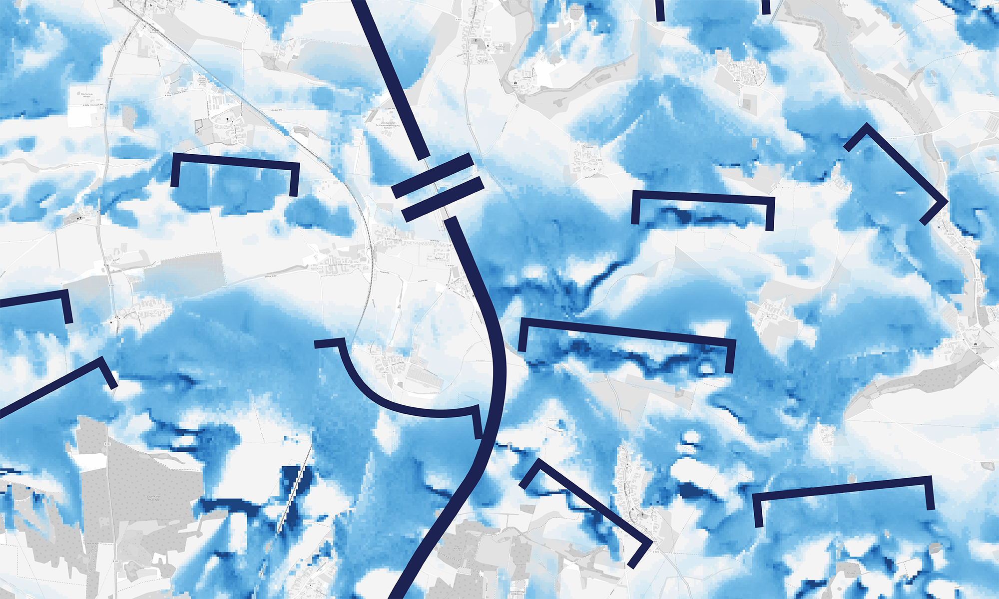
The SWA covers the top 5% of the area

The Position Selection Assistant automates terrain assessment—using AI and drawing on the experience and procedures of soldiers. The analysis now takes only a few minutes. The result is a precise map that shows at a glance which positions offer maximum effectiveness with optimal cover. Reconnaissance is targeted. Unsuitable locations are not even approached. This leaves more time for quality and leadership tasks—and soldiers remain in cover longer.


Manufacturing process and technical parameters

Freely available terrain data, known as digital elevation models, form the basis for automated terrain analysis. The analysis takes into account:

  • Field of fire
  • Cover
  • Passability
  • Direction of attack
  • Weapon system parameters

As a result, the user receives a georeferenced overlay that can be used in all standard command and control systems and geographic information systems (GIS). Other results provided by the “Position Selection Assistant” include:

  • Positions with secure approaches and retreats
  • Prediction of enemy troop movements

This helps avoid positions in open terrain. The movement forecast simulates how enemy units move across the terrain—based on terrain characteristics and land cover. Areas with a high predicted troop density indicate chokepoints and key terrain, which is particularly relevant for further operational planning.

Field-tested: 5 times faster, 90% accurate

Several trials with soldiers confirmed the system’s operational value: “90 percent of positions are usable—that’s excellent additional information,” was the verdict for familiar terrain. One instructor estimated the time savings at a factor of five—reducing the task from about an hour to ten minutes. The area requiring analysis is reduced to five percent of the total area.

The system is particularly impressive under difficult conditions: “It allows positions to be determined much more precisely, especially at night or in conditions of limited visibility.” Even when reconnaissance is very difficult, the “Position Selection Assistant” provides a reliable basis for decision-making. Large-scale analyses are performed in a flash and support data-driven, AI-assisted combat operations.

Entwicklungsperspektiven

  • Faster calculations: Machine learning algorithms reduce computation time and enable real-time geo-analysis
  • More precise assessments: Assessment logic is fine-tuned to suit different military branches
  • Automatic planning: Operational plans as decision recommendations – fully automated

Collaboration and Further Development

Military agencies, training institutions, and research partners interested in testing the Position Selection Assistant or contributing to specific enhancements should contact the “Geo-Intelligence” group at Fraunhofer IOSB. The group focuses on AI-supported geodata analysis, GIS plugins, battlefield simulation, and digital twins of the terrain.  Consulting services for integration projects and application-specific customizations are available.


Department SZA of Fraunhofer IOSB

You want to learn more about our products in the field of Scene Analysis? Then visit the page of our department.


MilitAR-Sandbox

The "MilitAR-Sandbox" functions as a tangible user interface—an interface that makes digital data tangible through physical interaction.