This is how the idea of Coalition Shared Data (CSD) came about. It affords rights-based access to data (such as images,
reports, streams, tasks) from arbitrary sites in near real-time. The system normally distributes only metadata to save network resources, but actual information may be retrieved on demand. The German armed forces use our CSD technology on various missions.
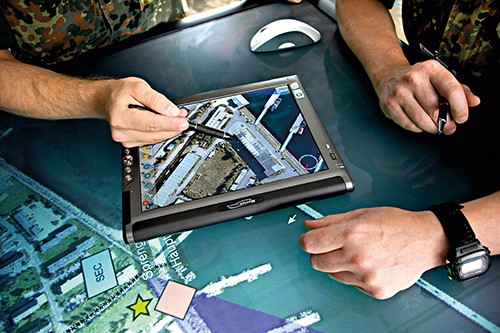
Our ABUL system provides automated image exploitation for unmanned aerial vehicles and has many features to lighten the operators’ workload. This system can feed in video streams from many drone types, stabilize them live, show them in a freely configurable representation, and store them in a database. Features include the merger of images into a georeferenced image mosaic, change detection, and tracking of marked objects even when they are temporarily obscured, stereo images and super resolution.
We commenced the development of the Digital Map Table to bring the many benefits of digital information flows to strategic and tactical operations centers. It is compatible
with all relevant data sources and is tailored to the needs of command staff and operation control centers. The Bundeswehr Command and Staff College, among others, puts it to good use. We have continued to improve the Digital Map Table, adding features and interaction techniques in many projects since. Command and field staff can work not only with conventional devices such as smartphones, tablets and the large physical Digital Map Table, but also in virtual space. The participants can see each other with VR headsets and a 3D representation of the scenario and can interact quite naturally despite being widely separated in reality.